
Your download link has expired — please click the download button again.
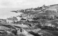
The Cornwall Coast
by Arthur L. (Arthur Leslie) Salmon
- Language
- EN
- Format
- EPUB
- Size
- 2 MB
Description
This work is a travelogue that combines descriptive narration with practical guidance. It is composed of detailed accounts of various regions along Cornwall's coastline, including towns such as Looe, Fowey, and Polperro, as well as the natural features and historical sites of the area. The author examines the geological and geographical aspects of Cornwall, highlighting coastal formations and natural history, and provides insights into travel conditions and routes. The narrative aims to assist visitors in understanding the landscape's features and legends, offering both cultural context and useful tips for exploration.
Published in the early 20th century, the book reflects the period's approach to travel writing, blending scientific observations with personal observations. It serves as a guide for travellers interested in the natural and cultural landscape of Cornwall, emphasizing scenic views and regional significance. The work is part of the travel literature genre, capturing the character of Cornwall during that era.
Published in the early 20th century, the book reflects the period's approach to travel writing, blending scientific observations with personal observations. It serves as a guide for travellers interested in the natural and cultural landscape of Cornwall, emphasizing scenic views and regional significance. The work is part of the travel literature genre, capturing the character of Cornwall during that era.
From the opening pages
Those who travel through Cornwall by cycle or motor-car will usually find very good roads, but for the most part these only touch the coast at special points; and in some cases it will be wise to leave bicycle or car at hotel or farm if the coast is to be fitly explored. The study of a map will show the tourist what to expect, and he may note the parts where, if he thinks of easy travelling alone, he will have to desert the sea. But by a judicious use of high-road and by-road he need never be far from the shore, and in some places the road that is actually best for him gives fine views of the coast. There are many excellent maps issued, but it is best to go to the fountainhead, to the publications of the Ordnance Survey. For the pedestrian those of one inch to a mile are admirable; but the cyclist or motorist will find the two miles to an inch more handy, as covering a wider range; and even those of four miles to the inch are sufficiently full for the motorist. If any special district is to be carefully explored, the one mile to an inch should be carried, but the wise rider will not content himself with a map of a single scale; he should at least carry one for the entire Duchy and others for the sections. The maps of the Ordnance Survey for Cornwall are as follow:— One mile to the inch, large series, in sheets about 27 × 18 inches, paper (flat or folded), 1s. 6d. net; mounted, 2s.; cut into sections and mounted to fold, 2s. 6d., Nos. 139, 146–7–8, 151–2. One mile to the inch, small series, in contoured outline, with hills shaded or coloured, Nos. 347, 353, 1s. 6d. and 2s.; 348, 354, 1s. and 1s. 6d.; 322, 336, 1s. 6d. and 2s.; 335, 346, 1s. and 1s. 6d.; 351, 359, 1s. and 1s. 6d.; 352, 360, 1s. 6d. and 2s. These may be had flat or folded. Two miles to an inch (flat or folded, or on the new layer system), Nos. 35–6, 1s. 6d., 2s., 2s. 6d. Four miles to the inch, Cornwall, 1s. (flat or folded). Four miles to the inch, Nos. 21, 22, 1s. 6d., 2s. (flat or folded). Ten miles to the inch, No. II. (flat or folded), 1s.,…
FAQ
Is "The Cornwall Coast" free to download?
Yes, it is free to download — no sign up needed.
What format is the file?
EPUB.
Similar books


Reader reviews Be the first
No reviews yet. Be the first to review this book.
Write a review
Protected by reCAPTCHA.